


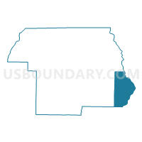
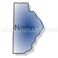
16-Voting District, Jackson County, Florida
About
Outline

Summary
| Unique Area Identifier | 554219 |
| Name | 16-Voting District |
| County | Jackson County |
| State | Florida |
| Area (square miles) | 62.90 |
| Land Area (square miles) | 52.51 |
| Water Area (square miles) | 10.39 |
| % of Land Area | 83.48 |
| % of Water Area | 16.52 |
| Latitude of the Internal Point | 30.68874110 |
| Longtitude of the Internal Point | -84.94276410 |
Maps


Graphs
Select a template below for downloading or customizing gragh for 16-Voting District, Jackson County, Florida


Neighbors
Neighoring Voting District (by Name) Neighboring Voting District on the Map
- 1-Voting District, Liberty County, FL
- 10-Voting District, Jackson County, FL
- 2531 - PRECINCT 1 Voting District, Seminole County, GA
- 26-Voting District 26, Gadsden County, FL
- 3-Voting District, Calhoun County, FL
- 8-Voting District, Jackson County, FL
- 8-Voting District 8, Gadsden County, FL
- 9-Voting District, Jackson County, FL
- 9-Voting District 9, Gadsden County, FL
Top 10 Neighboring County Subdivision (by Population) Neighboring County Subdivision on the Map
- Sneads CCD, Jackson County, FL (6,274)
- West Liberty CCD, Liberty County, FL (6,258)
- Chattahoochee CCD, Gadsden County, FL (5,664)
- Cypress CCD, Jackson County, FL (5,342)
- Steam Mill CCD, Seminole County, GA (2,604)
- Altha CCD, Calhoun County, FL (2,433)
Top 10 Neighboring Place (by Population) Neighboring Place on the Map
Top 10 Neighboring Unified School District (by Population) Neighboring Unified School District on the Map
- Jackson County School District, FL (49,746)
- Gadsden County School District, FL (46,389)
- Calhoun County School District, FL (14,625)
- Seminole County School District, GA (8,729)
- Liberty County School District, FL (8,365)
Top 10 Neighboring State Legislative District Lower Chamber (by Population) Neighboring State Legislative District Lower Chamber on the Map
- State House District 7, FL (169,309)
- State House District 8, FL (152,934)
- State House District 149, GA (43,458)
Top 10 Neighboring State Legislative District Upper Chamber (by Population) Neighboring State Legislative District Upper Chamber on the Map
Top 10 Neighboring 111th Congressional District (by Population) Neighboring 111th Congressional District on the Map
Top 10 Neighboring Census Tract (by Population) Neighboring Census Tract on the Map
- Census Tract 2109, Jackson County, FL (6,274)
- Census Tract 9502, Liberty County, FL (6,258)
- Census Tract 204, Gadsden County, FL (5,664)
- Census Tract 2110, Jackson County, FL (5,342)
- Census Tract 2003, Seminole County, GA (2,604)
- Census Tract 101, Calhoun County, FL (2,433)
Top 10 Neighboring 5-Digit ZIP Code Tabulation Area (by Population) Neighboring 5-Digit ZIP Code Tabulation Area on the Map
- 32351, FL (17,486)
- 32424, FL (7,994)
- 39845, GA (7,871)
- 32321, FL (6,460)
- 32460, FL (5,856)
- 32324, FL (5,445)
- 32442, FL (3,699)